|
With the slow death of illegal Landscape Conservation Cooperatives (LCC), the regrouping of the organizations that comprised LCCs, and new funding from foundations for continued work, the pursuit of taking land continues. The Western Governors Association (WGA) was established in 1984 and is comprised of Governors from the western half of the United States including 19 states and 3 US territories. Their mission includes addressing policy and governance issues, advancing "the role of western states in the federal government", and strengthening social and economic factors in the region, including developing policy on natural resources, and the environment. WGA creates a multitude of "resolutions" and "initiatives", one of which cannot be found on their website, the 2008 Wildlife Corridors Initiative. The initiative eventually established the Western Wildlife Habitat Council, which was responsible for creating the Crucial Habitat Assessment Tool (CHAT) for data collection. Another tool for data collection by this initiative was the Decision Support System that maps all layers of the environment. Just a brief summary, all of this established the framework for non-governmental organization (NGO) objectives to justify the creation of wildife and other migratory corridors, identifying land for connectivity conservation, which ultimately leads to land that cannot be used and is government controlled. This activity was accomplished without any voice from Idaho citizens. Does anyone remember these activities being brought to Idahoans for consideration, or any legislation for the same? Without going into depth on regionalism, this whole scenario is one fine example of how regionalism works and why it is so evil. Regionalism is a group of unelected individuals making decisions that bypass our representative government at all levels. This conglomerate of Governors, with their "collaborators", have created, built upon, and established policy and direction for states to meet NGO objectives, without any citizen involvement. It is also an absolute erasure of jurisdictional boundaries. For those not familiar with regionalism, better start understanding this is how our government now works, not through representation or as a Republic. Fast forward to 2019. In the years since 2008, the WGA, federal government, and NGOs have collectively created the framework for migratory corridors, and now all of it just needs to be executed. A celebratory love fest of accomplishments was recently held through the WGA Roundtable. While several issues were part of the 2019 WGA Western Working Lands Roundtable, only one will be the focus here, Migration Corridors. In each of the issue areas it should be noted the Roundtable consisted only of NGOs and several state and federal agencies, with no citizen representation. That is how regionalism works, and NGOs are gearing up for the assault on state legislators to advance their objectives. The Migration Corridors panel members included Jim Heffelfinger, Arizona Game & Fish; Paul Ulrich, Jonah Energy, who is also a Nature Conservancy trustee; Matthew Skroch. Pew Charitable Trusts; and David Willms, National Wildlife Federation (NWF). While the video is worth watching, here are some highlights. The panel essentially described how collared wildlife were used to identify the intensity of where migratory corridors exist, subsequently creating and funding "mapping teams" that have been "embedded" in each state to identify corridors. "Partnerships" between states, federal agencies, NGOs, and industry were emphasized with a paltry nod to involving more land owners. Exaggerated numbers of wildlife vehicle collisions were given for justification of using transportation as a way in which to improve wildlife connectivity. It wasn't just about wildlife corridors however, there was also emphasis on habitat that is needed for wildlife survival. Bottom line on all of this, the agenda has already been predetermined and set. One of the most pathetic parts was David Willms stating we "didn't know migration routes existed until recently". What rock has he been living under? Ask any person who lives in more rural areas when wildlife migrate and they can tell you the species, time of year, and where. Since NWF is an United Nations NGO, and participant, Mr. Willms presentation was dripping with UN ideology pointing out corridors were an economic and "social responsibility" issue for "future generations". He also claimed "wildlife belong to everybody", "tourists come from all over the world to see wildlife", and world wildlife populations have decreased "50%". The Sage Grouse initiative was cited by Mr. Willms as the "blueprint" for corridors as it protected the habitat, stating it was a success. Perhaps he doesn't understand that poor land management as a result of that initiative resulted in the Soda Fire, destroying thousands of acres of land, not to mention the habitat and the grouse. To suggest this as a blueprint for future corridors is reprehensible, and a ominous threat to Idaho. During the Roundtable on Coordination Between Federal Agencies, Kristin Thomasgard-Spence from the Department of Defense described their Readiness and Environmental Protection Integration Program (REPI) which buys land easements around military installations, citing "encroachment" as interfering with training. Not to be left out, the U.S. Fish & Wildlife Services has their own land acquisition program (Pg LA-4), and recently published a federal register notice to collect private data on land owners, including financial information and social security numbers, to be used for future land acquisitions. Of interest also is the panel discussion on Natural Resource Data Management and Landowner Privacy, which included the UN NGO Environmental Defense Fund, discussing the "mistrust" of land owners sharing information about their land, but once "relationships" are developed what wonderful work they can accomplish together. Landowners beware, don't fall for it, don't allow them on your property for data collection, and don't become friends with them.
They aren't fooling anyone, no matter how they fluff it, the goal is taking as much land as possible for government and NGO control. NGOs are reorganizing, one of which is the Center for Large Landscape Conservation (CLLC), having now become "global" with Idaho as a target, and openly admitting to their UN involvement. CLLC recently announced their partnership with the National Caucus of Environmental Legislators (NCEL). This partnership includes Idaho legislators who can be found here. The CLLC goal is "developing legal policies and provisions to advance corridors and connectivity conservation areas at the international, federal, state, and local level." Get to know those Idaho legislators who are involved in this. The destruction of our Republic with regionalism was given to us by WJ Clinton in 1993 with the establishment of the President's Council on Sustainable Development (PCSD) which implemented Agenda 21. Chapter 5 and 4 are rife with NGO and regional collaboration. Federal and state governments, with UN created NGOs, are ONE, a trinity, blessing us by bestowing their gifts of taking more land for greater control. There will never be ANY resolution to ANY land issue until this is exposed, confronted, and eliminated. A very clear picture is described here about one agenda, how it began, its progression, who is involved, and how it is being accomplished. This is only a small slice of one agenda, there are a malignancy of others. The agenda is set, this is what they are doing, and NOTHING will change until Idahoans awaken to that fact. It is not NGOs, the federal government, or state legislators. It is these three groups working together against you, an oligarchy, that has already become YOUR government, and will continue to do so. It is time to stop sitting back and waiting to see what will be done to us next. Idaho is facing an even more ominous future if nothing is done to address the source of this problem.
0 Comments
The Northern Rockies Ecosystem Protection Act (NREP) has been reintroduced by a New York representative for the seventh time in Congress, and has been referred to the Natural Resources Committee. This bill, H.R. 1321, is another attempt at taking more land away from Idaho citizens for use and designating it as wilderness, wild and scenic rivers, biological connecting corridors, and for other purposes. Claiming that "wildlife treasures of the Northern Rockies are of international significance", the standard environmental group mantra is given that "fragmentation" of wildlife occurs due to roads, harvesting, and mining, all horse pucky. No international significance exists when it comes to Idaho land, it belongs to us. In the bill text, land is divided up into five ecosystems but the bill has nothing to do with ecosystem protection, it is about taking land. Each ecosystem includes Idaho national forests, and all are impacted. Affected areas incorporate land and creeks into currently existing designated wilderness areas and national forests, designate new wilderness areas into what is called the "National Wilderness Preservation System", take land for "biological connecting corridors", all of the areas being too exhaustive to list here. Also defined is "no new road construction or reconstruction, or timber harvest (except firewood gathering) shall be allowed in the lands". Everyone should take the time to see how their own particular area would be affected. One non-governmental organization (NGO) that has put much effort into increasing federally protected land is the Greater Yellowstone Coalition (GYC), which covers the Greater Yellowstone Ecosystem and Greater Salmon/Selway Ecosystem, both listed in the bill. GYC is out of Bozeman, Montana, but is also registered in Idaho. Kathy Rinaldi is the Idaho Conservation Coordinator for GYC, and Allison Michalski is the Idaho Conservation Associate. Their focus is "protecting" lands in Idaho from eastern Idaho through the Salmon area. Areas they focus on are included in the bill such as the Custer Gallatin National Forest, and water protection. In the first 10/1/16-9/30/17' tax return posted below, with a net balance of 10,813,967 dollars, the GYC spent $118,957 in "direct lobbying" to influence a legislative body. $18,788 was spent on "grassroots" lobbying, which is an indirect way of influencing legislative bodies through their members. Another fact found in their tax return is the donation of $27,500 to the National Wildlife Federation, Idaho being an affiliate, for a "grazing allotment buyout", land that will most likely never be used again. GYC proudly boasts about convincing the U.S. Forest Service (USFS) to protect Grizzly habitat while partnering with them on other issues, shutting down sheep grazing, and again buying out grazing allotments. Is it no wonder that citizens have no voice on land use when NGOs such as GYC and others have the pocketbook and relationships to get what they want? Giving money to the USFS (pg 30) is just one way as they also partner with Idaho Fish & Game (IDFG), having even been on the "core team" for the development of the State Wildlife Action Plan (Rinaldi, page xii). For an unknown reason, other than a request for an extension on tax filing, the GYC website lists a different tax form for the same year. In this form, lobbying expenses for the same period came to $116,300 in a payment made to a Washington D.C. lobbying firm, Forbes-Tate Partners. Given the drive for protecting land, did the GYC lobbyist have anything to do with the reintroduction of NREP or the recently signed S. 47?
In the tax forms, GYC specifically states one accomplishment as "permanently protecting Yellowstone's northern gateway from two proposed gold mines", that was in 2017. GYC took credit for the passage of the 2019 Yellowstone Gateway Protection Act that was included in S. 47. President Trump just signed this bill, effectively endorsing the GYC goal of shutting down all gold mining activity north of Yellowstone Park. Do they hold the same lobbying power to take thousands of acres of land for wilderness through NREP? Other accomplishments listed in the tax form, "conserving public lands...in the Gallatin Range...and...High Divide", and new protections on BLM lands. Water is another focus for "permanent" protection. All of these are addressed in the NREP bill. As a partner with Yellowstone to Yukon (Y2Y), which is a IUCN member and supports IUCN objectives for protecting large areas for conservation, GYC is in charge of implementing those IUCN objectives within the Greater Yellowstone Ecosystem and Salmon-Selway Ecosystem. Representatives Russ Fulcher and Mike Simpson are both members of the Congressional Western Conference (CWC), although Rep. Simpson is known for his alignment with NGOs and support for land grab legislation. CWC has a multitude of issues that it covers, one of which is federal land management, claiming too much land is controlled by the federal government and the "checkerboard" of land ownership should be streamlined. Yet at the same time, this group applauded the passage of S.47, which establishes more national monuments, designates more wilderness areas and wild and scenic rivers, restores the Land and Water Conservation Fund which is used for land purchases by the federal government, and provides money to NGOs for continuation of their agenda. Taking more land is being justified by increased access to public land use "unless specifically designated otherwise". Should the CWC be trusted to oppose NREP, or have GYC lobbyists and others successfully infiltrated, or bought, the caucus? NGOs have become so financially powerful they are now buying logging industries. From all accounts, it is clear that the federal government has only one intention in mind, take more land and restrict use, leaving citizens they represent out, instead building and funding NGO partnerships to accomplish their goals. NREP is just another example of how we are being robbed of our land. Let your representatives, CWC, and the House Committee on Natural Resources know that you oppose more land being taken from us and their support of NGO agendas. Some time has passed since exposing the Great Northern Large Landscape Cooperative (GNLCC) and with new events it is time to take another look at just how pervasive, diabolical, and advanced this agenda has become. As a reminder, in 2010 the Obama administration, via a memorandum, directed the US Department of Interior (DOI) to create large landscape cooperatives. Twenty two cooperatives were created in the US without any congressional authorization. What was not previously revealed is that the Canadian government was included in these cooperatives. As seen in the map below, the GNLCC stretches from Colorado into British Columbia and western Alberta, where the same aggressive methods are being used in both countries, by the same groups and individuals, that puts land into large landscape conservation, including restricted use, for connectivity. 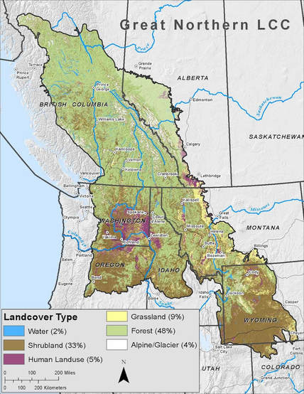 These cooperatives are a "regional" approach to landscape conservation that ignore the boundary between our countries and jurisdictional authority. Meant to be an "international network", the GNLCC covers 300 million acres, a network of U.S. federal agencies, Canadian provincial and federal governments, and conservation initiatives. GNLCC members include Canadian and U.S. land trusts, Yellowstone to Yukon Initiative (Y2YI), Heart of the Rockies (HOR), Crown of the Continent (COC), government agencies such as the Alberta Government, Environment Canada, British Columbia, and our own USFS, USFWS, and USGS. These LCCs were initiated without our knowledge, involvement or consent, or congressional approval and give tremendous authority to conservation initiatives. Concealed from both countries, this is the primary force behind our land being taken from us for our use, and why conservation initiatives have more influence over our governments than us. Sec. Zinke supports these LCCs. The LCCs were originally created under Secretarial Order (SO) 3289 by Sec. Salazar, then advanced by Sec. Jewell with SO 3330. In 2017, President Trump directed the DOI to revoke "agency actions" by the Obama administration. Sec. Zinke responded with SO 3349 which did revoke SO 3330, stopping all LCC activity. But Sec. Zinke then immediately issued SO 3362, reinstating and expanding LCC activity that he just revoked, omitting citizen involvement except to put fencing up, and allowing conservation initiatives to continue their work with our governments for large landscape conservation, including the creation of corridors. Since that time the conservation initiatives have upped their game, becoming more aggressive with attempts for land use restrictions, hiring more staff to target areas in both countries, expanding their media assault in Canada, and even advertising Idaho Fish & Game jobs. Sec. Zinke even wants to plant his staff into our states with his reorganization to further the conservation agenda. Basically, GNLCC believes land is "fragmented" by development, impeding the movement of wildlife. Protected areas such as national parks and wilderness areas are "isolated" from each other, meaning the land in between must be placed into conservation so that there is a "link" between the protected areas for "connectivity". Unprotected areas are targeted for linkage using wildlife, habitat, aquatic, riparian, and ecological as the ruse. As an example, the British Columbia Ministry of Environment, Idaho Fish & Game, Idaho Transportation Department, U.S. Fish & Wildlife Service (USFWS), and Nature Conservancy participated together in a study to identify linkage areas in 2012. As a GNLCC partner, Yellowstone to Yukon (Y2Y) also works to identify linkage zones. Here is a short video explaining connectivity. To eliminate fragmentation the GNLCC and its partners target unprotected land with conservation easements, banning use such as for OHV and snowmobile users, and putting land into various categories of corridors such as for wildlife and habitat. If an area can be declared a corridor (pg 11), it is then used as a basis for wildlife movement protection, or what they call a migratory corridor. With that protection comes restricted or banned use, with justification for restrictive land use policies nearby, including how a private property owner can use their land. According to Y2Y, "Areas which are identified as core and connectivity habitat, are the focus of restrictive management practices on public lands, and are the focus of land acquisition and conservation easements on private lands." Once a corridor is designated the next objective by GNLCC partners is extending the corridor to adjacent land, including private property, or procuring a conservation easement, expanding their restrictive land use policies. Anything goes for linkage. The players are all the same, Harvey Locke, Gary Tabor, Kim Trotter, Candace Batycki, Stephen Lagault, and others from both countries, all work towards achieving GNLCC goals. In this document you will see GNLCC objectives for both countries including obtaining land for protective status, interfering with local land use policies, and restricting energy development. The Government of Alberta - Environment and Sustainable Resource Development is an active participant with the COC which extends from Montana into western Alberta and British Columbia. Targeted areas for connectivity are also mapped out. Crown Managers Partnership (CMP) members include Alberta Environment and Parks, Alberta Agriculture and Forestry, British Columbia Ministry of Forests, Bureau of Land Management, and U.S. Fish & Wildlife Service (USFWS). Canadian and U.S. government employees sit on the CMP leadership team and the GNLCC funds them. The CMP has a "Transboundary Conservation Initiative" that does not include involvement by Canadians or Americans. Both of our governments are working on targeting species at risk, or species of greatest conservation need. The species and their habitat will be used as justification for conservation, taking more land use away from us, and affecting private land owners. As a partner to the UN participant, International Union for Conservation of Nature (IUCN), the USFWS, Canadian government, Y2Y, Harvey Locke, and Gary Tabor bring IUCN objectives and ideology back to our countries, one of which is addressing "threats' to wildlife, habitats, wetlands, etc., while advocating for special land protections for different categories and connectivity. On September 2-3, 2015 the GNLCC held a meeting on their connectivity initiative laying out the larger picture for restricted use and banned access as seen in the box below. 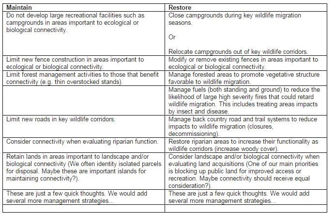 The Cabinet-Purcell Mountain Corridor (CPMC) will be used as a transboundary link connecting wildlife between British Columbia and Idaho. Here are all GNLCC focal areas. 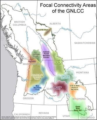 Both Canadians and Americans need to be aware of this GNLCC agenda, coming straight out of the UN, that includes unauthorized partnerships between our governments and conservation initiatives. We have lost all representation by our elected officials, including Sec. Zinke. Our governments are partnering with groups that have specific UN goals to take our land from us, restrict or ban the use of our land, and eventually dictate how we will be allowed to use our land. It is time all of this is exposed for both Canadians and Americans and action taken to confront and stop it.
In addition to reinstating large conservation cooperatives (LCC) after revoking them through his Secretarial Order 3349, Sec. Zinke now has grand plans to reorganize the Department of Interior (DOI) which will further erode state sovereignty.
The essence of reorganizing is redrawing "regional" boundaries and moving employees out of D.C. into those regions for closer "collaboration" with states for streamlining DOI efficiency. There have been some accusations that he is gutting the DOI. DOI regional boundaries as of December 22, 2017 are outlined in the map below. 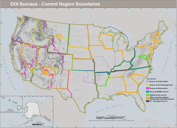
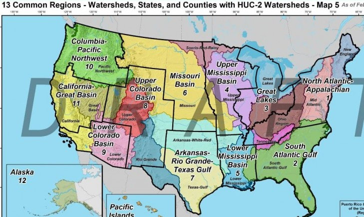
Sec. Zinke initially reorganized departmental regions based on watersheds and ecosystems, reducing 40 regions down to 13. The first revised regional map based on that concept is below. Montana had specific issues with the state being cut in half by these boundaries.
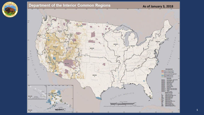
The Western Governors Association (WGA) objected to the watershed, ecosystem idea for boundaries, writing a letter to him requesting regional boundaries were based instead on state boundaries. Given one of his initial reasoning for reorganization was partly based on working more closely with states, it is ironic that he failed in the first step to create these boundaries with WGA involvement. What does that tell you? WGA also commended him on "...your addition of the goal of improving coordination among federal, state and local agencies...". That is an interesting statement as federal law has specific coordination requirements for local governments which is different from federal and state coordination. Multiple other associations joined with the WGA and signed the letter to Zinke. Oddly enough, as a result, Sec. Zinke decided to refine his regional boundaries more closely along state lines as seen below. The WGA was "gratified" with the new map.
Many questions have arisen with the new DOI plan. Sec. Zinke's plan is to assign an Interior Regional Director (IRD) in each region, whose responsibility will include coordination of missions and administrative functions between bureaus within the region. While special consultation with Tribes is mentioned, there is no mention of consultation with local governments or citizens.
Drawing boundaries along watersheds was the original intent, however the new state boundary alignment does not necessarily change that intent, "...new regional watershed-based boundaries are often adjusted to line up with the nearest state boundaries." As Sec. Zinke explains in this video, his thoughts about placing land into federal protection as did Theodore Roosevelt, and John Wesley Powell's notion of land preservation and conservation, should give a clear picture of what he intends to do. Sec. Zinke adds to this with his intent to create wildlife corridors which would also cross state boundaries.
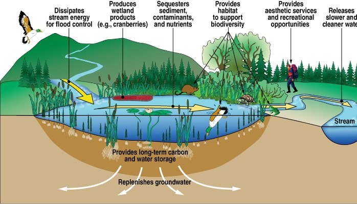
The problem with reorganizing along ecosystems and watersheds is that there is no defined boundary between federal, state, and private land. Unlike a specific tree line or boundary that can be drawn on land as it is now, an ecosystem often has no clear boundaries due to it flowing into another ecosystem, therefore an ecosystem must be managed as it has an ever flowing connection with everything. As seen in the map below, there is no clearly defined boundary between the ecosystem elements and watersheds, they are continuous and connected. Disrupting one part affects the rest. Ecotone is a term used to describe transitions between different ecosystems but is not necessarily a boundary.
According to environmentalists, no boundaries exist in landscapes because of connectivity, and boundaries such as county and state lines that define us become irrelevant. That is essentially what Sec. Zinke is planning, creating large regional ecosystems that includes connectivity between them, providing ecosystem management, and crossing over all jurisdictional boundaries. If an ecosystem needs restoration, flowing into another over state or private land, how will Sec. Zinke manage that? If consulting and collaborating with states, it seems that the IRD will possibly need to interfere with state sovereignty for ecosystem restoration and protection.
As noted in Secretarial Order 3362, Sec. Zinke wants to "...harmonize State fish and game management and Federal land management of big game winter range and corridors.", and establish "...a clear direction forward with each State...". He wants to plant federal agents in each state to help bind us further together with the federal government. Where did he formulate the idea that the DOI determines the forward direction of our state? Our Founding Fathers must be turning over in their graves. As a International Union for Conservation of Nature (IUCN) member, Sec. Zinke will most likely bind us to their notion of ecosystems and managing them through DOI agencies. The IUCN already has a Red List of Ecosystems with categories and criteria for micromanagement on restoration and protection. As yet, this reorganization has not been approved by Congress. If you would like to provide feedback on this reorganization, you can contact the DOI here. Let Sec. Zinke know that we have sovereignty and do not want the federal government coming to our state for harmonization between state and federal policies, and that Idahoans will decide how our land is managed.
It is understood that all conservation initiatives and non-governmental organizations (NGO) are attached to Washington D.C., they hob nob together, make their devious plans in partnership, and leave us out.
With the exposure of activity behind the Great Northern Landscape Conservation Cooperative (GNLCC), Yellowstone 2 Yukon (Y2Y), High Divide (HD), Greater Yellowstone Coalition (GYC), and others behind their conservation and connectivity agenda, Department of Interior (DOI) Secretary Ryan Zinke has now incorporated them into the DOI workforce. Created by DOI Secretarial Order 3289 and implemented by the US Fish & Wildlife Service (USFWS), these initiatives partner through the GNLCC, and it is a distinct probability that the DOI was advised of this exposure and investigated it. What better way to solve this exposure problem than to wave a magic wand and create a Secretarial Order (SO) that gives the GNLCC de facto authority to continue operating. Even the Greater Yellowstone Coalition understands this. On February 9, 2018, while attending the Western Conservation and Hunting Expo in Salt Lake City, Utah, Sec. Zinke announced his SO 3362, which is meant to "...improve habitat quality and western big game winter range and migration corridors for antelope, elk, and mule deer."..."...expand opportunities for big-game hunting by improving priority habitats...", foster "...collaboration with states and private landowners and...ensure that robust big game populations continue to exist."...and "...help establish better migration corridors...". What a bunch of crock. In spite of all the lauding of his accomplishments on the DOI site, Sec. Zinke just pulverized anything positive for Idahoans with this SO. This SO isn't about access to hunting, it is about putting land into conservation which leads to control over land use. As "partners", the DOI agencies USFWS and National Park Service (NPS) give conservation initiatives authority in the GNLCC. Primary objectives of the GNLCC are conservation of large landscapes and creation of corridors for connectivity. Essentially, Zinke just gave full authority to the GNLCC to continue in spite of the fact he revoked LCCs with SO 3349, which were created by SO 3289, and then advanced with SO 3330. SO 3362 essentially reinstates and expands what he just revoked as a directive that still has no legislative authority. There are several key sections of the SO 3362 that require scrutiny. Sec. 1 Purpose. This Order directs appropriate bureaus within the Department of the Interior (Department) to work in close partnership with the states of...Idaho...to enhance and improve the quality of...migration corridor habitat on Federal lands...that recognizes state authority to conserve and manage big-game species and respects private property rights. Our Republic does not include federal partnerships with states, states are sovereign. Nowhere does this SO state that citizens or local governments are involved in these decisions, or those who would be the most impacted by land use changes. Private property is a right and protected by the Fifth Amendment and Idaho law, it is not something that can just be "respected" by a federal agency. If the DOI truly recognizes state authority then why the "partnering"? Page two states, "...it is crucial that the Department take action to harmonize State fish and game management and Federal land management of big-game winter range and corridors...if landowners are interested and willing, conservation may occur through voluntary agreements." Translated this means federal policy will become state policy, "harmonize". As a DOI program, the GNLCC is also being used to incorporate their objectives into State Wildlife Action Plans (SWAP), and while landowners may be duped into "voluntary" agreements for conservation, initiatives work to get those conservation land use policies into local comprehensive plans, which will eventually become mandatory. 3c "Within 180 days, develop a proposed categorical exclusion for proposed projects that utilize common practices solely intended to enhance or restore habitat for species such as sage grouse and/or mule deer...". This essentially gives authority to maneuver around NEPA requirements, one of which is public participation. Sec. 4.a.(1) ...identify an individual to serve as the “Coordinator” for the Department. The Coordinator will work closely with appropriate States, Federal agencies, nongovernmental organizations, and/or associations to identify active programs focused on...migration corridors. Again there is no citizen or local government involvement and the "and/or associations" is clearly referencing the DOI created GNLCC. This SO cements their authority and now drags in state agencies whose role up to this time has been fairly hidden in the GNLCC. Idaho Fish & Game (IDFG) will more than likely be playing a larger role in the federal agenda for placing land into conservation. 4.b.(1) With respect to activities at the State level...identify one person...to serve as the Liaison...will schedule a meeting with the respective State fish and wildlife agency...work in close partnership with the State on...migration corridor conservation. Take note of that "conservation" wording. This is a Freudian slip by Zinke, the SO is really targeting land conservation, not improving big game hunting. IDFG already has a wildlife conservation program, one for "landowners", and a Habitat Improvement Program for private land owners. Now a federal "Liaison" will be interfering in these state programs. 4.b.(4) Assess State wildlife agency data regarding wildlife migrations early in the planning process for land use plans and significant project-level actions that bureaus develop.... As previously stated, the goal will be harmonizing federal planning with state planning, we will be living under federal policy "that bureaus develop". 4.b.5(iii) working cooperatively with private landowners and State highway departments to achieve permissive fencing measures, including potentially modifying (via smooth wire), removing (if no longer necessary), or seasonally adapting (seasonal lay down) fencing if proven to impede movement of big game through migration corridors; Zinke just gave the GNLCC and conservation initiatives the authority to continue their camaraderie with the Idaho Transportation Department for integration of wildlife overpasses and fencing, forcing wildlife into different migratory paths, both which lead to the creation of a wildlife corridor and ultimate land use control. 4.b.5(iv) avoiding development in the most crucial winter range or migration corridors during sensitive seasons; 4.b.5(v) minimizing development that would fragment winter range and primary migration corridors;. There it is, the truth, the goal is restricting use or banning land development within or adjacent to a migratory corridor. 4.d.(3) Consult with State wildlife agencies and bureaus to ensure land use plans are consistent...to one another along the entire wildlife corridor...where...migration corridors span jurisdictional boundaries. Zinke is referring to local comprehensive or land use plans, and jurisdictional boundaries includes private property. It is critical that citizens engage with elected officials on comprehensive plans, ensuring no reference is made to corridor protection or conservation. If local land use plans do not reference these then federal policy for corridors and conservation will be inconsistent with local policy and the feds will have more difficulty proceeding with conservation policies until consistency is reached. Coordination is in federal law, written into USFS, BLM, and FHA (23 CFR 774.5) laws, that coordination shall occur between the federal and local governments to ensure consistency between land use policies. It is not consulting, cooperating, or collaborating because coordination puts the local government on an equal footing with the feds, not subordinate. The feds do not like this law, they would like to just mow over local governments and us with their plans, without coordination, The 10th Amendment guarantees this protection for states and its citizens and recently the Idaho Senate addressed the coordination requirement in SJM103. 4.b.5(i) Habitat management goals and associated actions as they are associated with big game winter range and migration corridors; This statement references the creation of other corridors which can include riparian, biodiversity, or ecosystems, potentially expanding federal control over land use because these habitat types extend from public land into state and private land. An example is his reference to "sagebrush ecosystems...other ecotypes...and sagebrush landscapes". Migration corridors require other types of corridors that support wildlife. A habitat management example is the Sage Grouse, of which sage brush protection was needed for its habitat. Translated, "Habitat Management" means conservation or protection. Not only will SWAP plans be used as they identify species and habitat of greatest conservation need, but Zinke also plans to use the Crucial Habitat Assessment Tool (CHAT) as a mapping tool for land use (4.c.). The subject of the SO is "Improving Habitat Quality in Western Big Game Winter Range and Migration Corridors". In that title where does it indicate the SO will "...expand opportunities for big-game hunting by improving priority habitats...". Priority habitats are those typically protected for a game species as in the Sage Grouse example. What is meant by "improved" priority habitats? Corralling wildlife with fencing and forcing them into different migratory paths? Moving all humans and development out of the way? Creating pseudo corridors that already exist and which already cross private property without any problems? The Landscape Conservation Cooperative Network (LCCN), of which the GNLCC is a member, is actively involved with the UN NGO, International Union of Conservation of Nature (IUCN), bringing IUCN ideology back to us. Gary Tabor is a partner with the GNLCC through his Center For Large Landscape Conservation (CLLC) and works as Specialist Group Leader for the IUCN. Rob Ament is also a IUCN member and contributes IUCN ideology to the GNLCC. Below is two short video from the IUCN website, part of a series of modules on Protected Area Law (PAL). When referencing protected areas, an example is the agenda currently underway to connect Island Park to Yellowstone National Park for an extension of protected land, using wildlife overpasses as the basis for a corridor. Sec. Zinke is using an SO to achieve IUCN objectives. And why wouldn't he, the DOI and USFWS partner with the IUCN, gives your tax dollar to them, while assisting with the implementation of Agenda 21.
Starting at minute marker 5:22 is Yellowstone 2 Yukon promoting IUCN ideology for connectivity.
This West Is Our West has an excellent article, written by Clifford C. Nichols, Is Zinke 'Migration Corridors' order the Endangered Species Act on Steroids? His article brings out some other pertinent points on the SO.
Sec. Zinke isn't fooling anyone. His goal is conservation and control over land use. It is appalling that all of this activity is hidden from us, stripping us of our "consent of the governed" role. Without any federal law he is sanctioning an expanded, behind the scenes, directive that further erodes our right to local representation and state sovereignty. Sec. Zinke, Idahoans have not given consent to your SO 3362. 
There has been, and what is now a very aggressive agenda, to take and control Idaho land. Idahoans may not realize the magnitude of individuals and organizations involved so this is an overview of some, but not all, to provide an understanding of the problem, and its depth. These organizations and individuals work in harmony with each other and some individuals traverse between groups providing direction on conservation issues. Currently, land in between protected areas is highly targeted for conservation. This can only be described as a coup d'état. Western Governor's Association (WGA) The WGA created Resolution 07-01 in 2007, Protecting Wildlife Migration Corridors and Crucial Wildlife Habitat in the West, "to strengthen the protection of wildlife migration corridors and crucial wildlife habitat in the west.". The Crucial Habitat Assessment Tool (CHAT) was created using GIS tools, then transferred to the Western Association of Fish & Wildlife Agencies (WAFWA). Here is the result of their work, the Chat map. Goal: Data Collection, creation of corridors, and conservation. Western Fish & Wildlife Agencies (WAFWA) Association of Fish & Wildlife Agencies (AFWA) WAFWA represents "Western Fish & Wildlife Agencies", including Canada. WAFWA is an "affiliate" of the Association of Fish & Wildlife Agencies (AFWA), however, IDFG is listed as a AFWA member with 13 employees on various committees. IDFG Director, Virgil Moore, was named AFWA President this year. AFWA, based in Washington D.C., "represents state agencies" on capital hill while its members include other countries, federal agencies, and UN NGOs (NAS, TNC, SCI). Goal: Conservation of species, enacting federal legislation to enforce conservation. Blue Ribbon Panel (BRP) The BRP, created in 2014 by Bass Pro shop founder John Morris and former Wyoming governor Dave Freudenthal, "represents the outdoor recreation retail and manufacturing sector, the energy and automotive industries, private landowners, educational institutions, conservation organizations, sportsmen's groups, and state fish and wildlife agencies." The BRP includes 26 business and conservation leaders, and is a conglomerate of lobbyists succeeding in in introducing legislation, H.R. 5650, Recovering America's Wildlife Act of 2016 which requests 1.3 billion dollars for conservation. One goal is creating policy options to fund "conservation of the full array of fish and wildlife species" via state SWAP plans and restructuring state fish and wildlife agencies. (BRP was renamed "Alliance for America’s Fish and Wildlife"-AAFW). Goal: Raise funds through corporations to support conservation efforts in states and through federal legislation, possibly influence how fish & wildlife agencies are structured, rather than keeping it as a state decision. Landscape Conservation Cooperatives (LCC) Created by the Department of Interior and administered by USFWS, these are partnerships between NGOs, federal and state government agencies, universities, and conservation initiatives to collect data on species, habitat, and land which will then be evaluated for conservation through creation of corridors for connectivity, and other measures. Goal: Identifying species and habitat for corridors which can be used to place large tracts of land into conservation for connectivity to other protected areas, convincing private land owners to place their land into conservation easements, buying land through NGOs and the federal government, erasing jurisdictional boundaries between counties, states, and countries, and creating a regional environmental governance. Lincoln Institute of Land Policy (LILP) The LILP, UN NGO, integrates theory and practice for public policy decisions on land use. They were responsible for the idea to bring all conservationists together in one group, "a collective voice for advancing the theory and practice of large landscape conservation", called the Network for Large Landscape Conservation, then rebranded as the Network for Landscape Conservation. They also brought in LCCs, USFS, USGS, BLM and other federal agencies to enhance funding through grants. The LILP believes in regionalism, that jurisdictional boundaries, and your representation through elected officials, are irrelevant. LILP focuses on building a large landscape community of conservation practice. Property and Environment Research Center (PERC) is another organization that tries to influence the use of private property and whom "policy makers" listen to, rather than you. Goal: Increase efforts to put all land into conservation for protection and connectivity, research land policy programs for public officials and others about the use of land, land regulation, and property rights, having a "more active role in the conversations that shape public policy decisions.", which also involves land trusts. Network for Landscape Conservation (NLC) The NLC includes individuals working across geographies, regardless of political boundaries, to conserve connected, ecological systems by partnering with multiple organizations and the federal government. Goal: Conserving land for connectivity. Center for Natural Resources and Environmental Policy (CNREP) CNREP is "known for their work in public lands policy, water law and policy, land-use planning, and cross-boundary resource management.", including large landscape conservation strategic frameworks for policy and action. Goal: Influence public policy on land issues. Conservation Science Partners (CSP) Research scientists in applied conservation science, collecting and developing new data for conservation practitioners, all to support conservation goals. Their partners include the federal government and several other sources cited in this article. Goal: Producing science that supports all forms of conservation and organization objectives. Conservation Biology Institute (CBI) CBI conducts conservation research and develops conservation tools, such as Data Basin, for collecting data that assists conservation agendas, and regional planning assessments to support conservation projects globally. Data collection includes protected areas, conservation easements, and high conservation value areas. Partners include foundations, the federal government, corporations, and universities. The DOI funded CBI to "assist in the strategic development and expansion of scientific information, analysis and support tools to benefit the LCC network and facilitate landscape conservation design." This tool is interoperable between LCCs. Core Data Basin information is free and also serves the HORI which is a land trust partnership for placement of private land into conservation. Goal: Create tools for conservation, provide a data center where all conservation data can be stored and accessible to conservation groups and individuals for promotion of conservation. HD, HOR, Y2Y, GYC, COC, FW, TNC, WS, HFLP, WCS, DOW, NWF All of these "initiatives" and NGOs, many being UN NGOs, have common goals, putting as much private land as possible into conservation easements, buying private land to retain or sell to the government as a conservation easement, declaring areas needing protection for species or habitats, identifying corridors between protected land for eventual linkage and connectivity, engaging as many private land owners as possible to use conservation practices on their land, indoctrinating the young on believing their conservation is the only answer, creating conservation by design on land, expanding boundaries of already existing protected land such as national parks, and engaging county commissioners to integrate restrictive land use regulations into comprehensive plans. TNC is even bringing in corporations to fund their goals, starting with UN business partner J.P. Morgan. There are multiple overlaps of individuals between these groups with some players being prominent leaders such as Gary Tabor, Rob Ament, Michael Whitfield, Joel Berger, and Matthew McKinney. Goal: Put all land into some form of conservation status with restrictive regulations on how land is used, expand protected land boundaries so wildlife has room to roam, procure as much land as possible. USFWS, USFS, BLM, NPS, NRCS, USDA The federal government partners with initiatives, organizations, and NGOs to accomplish conservation goals and regionalism. Each agency has a variety of programs for conservation. It is your tax dollar being used to fund these conservation groups. Eventually, all recreation and how you recreate will be "managed" for conservation and protection, as H.R. 3400, Sec. 305 describes. Goal: Use taxpayer dollars to assist groups to achieve their goals of conservation across county, state, and country jurisdictional boundaries while failing to represent Americans as public servants through elected officials, or engage them with transparency. Western Transportation Institute (WTI) WTI conducts research on roads to assist with identifying core habitats, dispersal corridors, restoring connectivity, and highway mitigation methods, under the guise of road ecology. Goal: Determine how your roads should be built and managed simultaneously with conservation groups. Foundations Aside from these groups taking your tax dollar to support their objectives, there are also wealthy foundations that contribute to the effort. Wilburforce, Brainerd, Pew Charitable Trusts, and Turner (UN partner) are just a few foundations that fork over money for conservation groups. Goal: Financially assist NGOs and initiatives in conservation objectives. What is interesting about these groups is there are legal requirements not being followed. This Legal Framework For Cooperative Conservation document outlines some legal requirements. There are specific requirements for public involvement but these groups create their own support groups with the same ideology, then proclaim them as public involvement. Public engagement, those individuals who live in a particular area, are never involved while engagement with state and federal agencies are hidden as well. Specific requirements for open and transparent disclosure are also required, but this rarely happens. As stated in the document, "These resources belong to the public", not the conservation groups. But that is what they believe, they own the land, it is theirs to manipulate, and hide what they are doing. The Federal Advisory Committee Act (FACA) is intended "to ensure that agency officials make policy decisions in open, deliberative processes rather than behind closed doors with undue influence by select stakeholders". However, this is exactly what has been happening, activity and decisions are being made with select groups and hidden from the public. In order to delegate authority to new entities, "Congress must specify the general policies under which the group operates and the restrictions limiting the group’s authority." LCCs, initiatives, and NGOs operate without any congressional policy, create their own policies while projecting an image of authority, are self directed with no oversight, while the public is not informed about the depth of involvement by so many groups, their intention to collect and share data for decisions on how we will live or use our land, or that the federal government is funding it with our tax dollar. Had we been informed would we agree to this egregious agenda? Would there be agreement to the end goal of placing the majority of Idaho into conservation with restricted use? Our Constitution is based on separation of powers. Therefore, federal "agencies may not “subdelegate” this authority to outside parties." But the federal and state agencies are subdelegating decisions to these conservation groups, allowing them to integrate their objectives into governmental decisions, and influencing our elected officials. Even worse, now there is a growing movement towards private sector management of our public land, which Secretary Zinke supports and is implementing with a recreation advisory committee. Is this a sub-delegation of our public land to outside interests? Will there be corporate influence over how the land is used which overrides the public whose tax dollars pay for public land use? There is also the audacity of the USFS being allowed to subjugate private land to public use for access to public land. The Fifth amendment clearly states, "Nor shall private property be taken for public use without just compensation." Matthew McKinney (CNREP), believes in regionalism, and has his own ideas about land, co-authoring an article, "The Emerging Role of Network Governance in Large Landscape Conservation". He and his coauthor claim, "No single entity has the authority to address these types of cross-boundary issues, resulting in gaps in governance and a corresponding need to create formal and informal ways work more effectively across administrative boundaries, land ownerships, and political jurisdictions." Network governance is intended to "supplement", not replace other forms of governance. Supplement is a broad term but most likely it is meant to be an insertion of his and other groups ideology for conservation and regionalism. By his own admission, "civic entrepreneurs from the public and private sectors, NGOs, and universities have catalyzed a variety of innovative governance arrangements". Has he ever heard of the Constitution, the foundation of which cannot be exchanged for other "governance arrangements? Mr. McKinney has written about "Global Guidance on Transboundary Conservation" for the IUCN and how to initiate it. As a Global Transboundary Conservation Network member, and World Commission on Protected Areas ( WCPA) member, Mr. McKinney has deep ties with the UN, especially regarding protected areas, bringing UN ideology into decisions regarding Idaho through his many connections. All of his activities are moving towards the UN Environmental Governance strategy, which the University of Montana might teach in their model UN program where Mr. McKinney works. This CSP graphic gives a visual picture of just a few who are involved in controlling our land use.  The majority of these groups and individuals are scientists, technocrats, implementing their agenda via technocracy, a government or social system that is controlled or influenced by experts in science or technology, or control of society or industry by an elite of technical experts. Most associate with the UN and are actively implementing Agenda 2030 SD target Goals 15 and 17.17.
Federal and state employees are public servants, hired to represent Idahoans through laws. Our Senators and Representatives are elected to represent our state, and us. But, the truth is, representation has been entrusted to other states, countries, corporations, organizations, and NGOs. Unless we come together, organize direct opposition to them, land use for "future generations" will be living with these individuals and groups deciding how land is used. We cannot let them continue taking control of Idaho land. One cannot escape the fact that NGOs, landscape initiatives, and other individuals are embedded with federal government agencies such as the US Forest Service (USFS) and Bureau of Land Management (BLM). These groups also have powerful lobbying within both the state and federal government with large amounts of money backing their efforts. Their voice has succeeded in overpowering citizen's voices.
Over the last several years these same groups have been studying the State Wildlife Action Plans (SWAP). The SWAP was created by each state, in Idaho by Idaho Fish & Game, and although they vary in focus the primary objective is identifying species and habitat of greatest conservation need (SGCN), threats to them, and proposing conservation plans that will be monitored for effectiveness. SWAP is seen as a "living" document that can be updated and revised at regular intervals depending on how the plan is working. These groups are scrutinizing those objectives to intervene during revisions. In 2012, the Department of Environmental Science & Policy, University of California, literally scoured 49 SWAP plans in the U.S., evaluating the language and content for keywords such as wildlife or habitat connectivity and linkage, and possible references towards incorporating these concepts into large-scale conservation plans. Corridors and movement were two other keywords that were counted. These groups see the SWAP as nothing more than an opportunity for a single framework, a national data set that evaluates and compares conservation planning efforts with no jurisdictional lines between or within states, only conformity with standards they want so desperately to define and control. Idaho would no longer be creating standards for Idaho, or standards that Idahoans want. Because some SWAP plans omitted this type of language it was seen as a hindrance to "...coordinated nationwide planning...". Eleven plans succeeded in meeting their criteria for what they consider best practices. This study was done for the purpose of identifying how SWAP plans could be revised to include more language and focus on the goals for connectivity and integration of what they consider are best practices, stating, "...increasing the emphasis on wildlife linkages, using common language, and incorporating these best practices can directly improve subsequent iterations of SWAP...". Since the Idaho SWAP is a "living" document with periodic monitoring for revisions these groups and lobbyists will be ready to make their case for the insertion of connectivity and linkage language into the plan. Since they are already tied into these agencies it shouldn't be very hard to accomplish. The Gary Tabor organization, Landscape Conservation Cooperative Network (LCCN), used the Gulf states SWAP to integrate their agenda, "...working to ensure that they play a foundational role in the GCPO’s Landscape Conservation Design (a.k.a. Conservation Blueprint). To that end the GCPO LCC has invited SWAP leaders to actively participate in the design process..." and "...will help ensure that the work the GCPO LCC does is value-added by integrating States’ plans across administrative boundaries...". The Great Lakes was another target. LCCN is literally drooling over SWAP plans for their pernicious agenda. The Greater Northern Landscape Conservation Cooperative (GNLCC), a federal program that coordinates these groups, also sees SWAP as "The first step towards integrating landscape efforts", along with the Defenders of Wildlife. This is how the game is played, study the prey, find an opening, then manipulate it for advantages in self-serving agendas. Idaho citizens will not have a say in this in spite of their right to representation. But Idaho Statute, Title 36 36-2405(5) states "The governor’s office of species conservation may petition the responsible public agencies to initiate rulemaking to facilitate the implementation of the approved management plan." and (7) "Nothing in this act shall be interpreted as granting the department of fish and game with new or additional authority." Since Governor Otter is part of the Western Governors' Association (WGA) that partners with the federal government for this conservation agenda, it is highly unlikely rulemaking will be requested. Citizen input for SWAP was not pursued aggressively as with scientists, NGOs, and other outside groups. A public hearing was held in Boise in January, 2016, a Wednesday and Thursday, when people are working, in the dead of winter. Idaho citizens should have first priority for input with these other groups taking a subordinate role. Per Idaho statute there is no authority to enforce SWAP and in spite of getting connectivity or linkage language into the SWAP there is no authority to force it on Idaho citizens. Individuals employed by NGOs and other initiatives work full time implementing their agenda while Idahoans work to earn a living, making it very difficult to find the time needed to oppose this agenda. But it must be done, now. Technocracy is "a system of governance where decision-makers are selected on the basis of technological knowledge. Scientists, engineers, technologists, or experts in any field, would compose the governing body, instead of elected representatives." The right to representation is removed from citizens while these "experts", also known as technocrats, believe they possess impeccable scientific knowledge and are therefore masters of all solutions. Land issues are the perfect example to describe technocracy implementation. Data gathering is the essence of technocracy, examining everything at a microscopic level, so miniscule that the broader picture is obscured. Technocrats believe every species, plant, speck of dirt, drop of water, and human on land needs detailed examination for ultimate management. This is all based on the irrational fear that humans will overpopulate, necessitating the conservation of land for humans that don't even exist. But the truth is, land is rich with resources needed for life. Because technocrats believe land and its resources will be consumed by too many humans, then both must be conserved and controlled, now. That is the deception. Once the data is collected, it will be used for the goal of controlling and managing all resources, and humans. Created in 2005 by the Idaho Department of Fish and Game (IDFG), the Comprehensive Wildlife Conservation Strategy (CWCS) was just for this purpose, bringing together a group of various technocrats for gathering data on species and habitat which might need conservation. Idaho was broken into fourteen "ecological sections", transcending all jurisdictional boundaries, with the next ten years spent on inventorying fish, wildlife, plants, and habitats, mapping their locations with geographic information system (GIS) layers for analysis. Scientific names were added to traditional names for wildlife and plants. A deer can no longer stand on its own as a beautiful creature, it has to be detailed as to type, what it eats, and where it lives. In ten years, with all this data stockpiled, what was a strategy now became a plan, the 2015 State Wildlife Action Plan (SWAP). While this discussion focuses on Idaho, the federal government funded SWAP plans in every state, and the agenda is the same. The list of technocratic "experts" was expanded for this plan. From the CWCS, 205 Species of Greatest Conservation Need (SGCN) were identified, along with their habitat, ecology, and threat information. Not being detailed enough these species were then placed into "tiers" with ranking for conservation need. Going further, species were detailed in each ecological section. For good measure, all vertebrates and invertebrates in the state were inventoried. The more details the better. This resulted in a 411 page document that describes in excruciating detail the species description, conservation status, population trend, habitat, threats, needed conservation action, and other laborious data which will be used to justify the need for regulations that will remove the threat, justifying continued need for conservation. IDFG will need to implement a monitoring system for any changes in this data and that includes more GIS data layers. Needing further detail, the effectiveness of the monitoring will need to be monitored. Adaptive management is used by technocrats to incorporate new information for managing species and habitats. Using "conceptual models", technocrats try to predict desired outcomes for different approaches in conservation to determine if a desired outcome is achieved. In other words, experimenting around with nature. 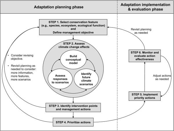 If any of these species or habitat are identified on private property, what will IDFG do? They will have to protect both by regulating your land. Will technocrats have that authority? Because of their power within government agencies technocrats are the likely ones that will make the regulatory decisions. 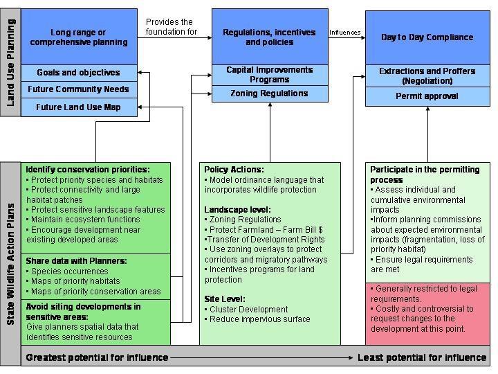 The graphic tells the truth, how microscopic data will lead to regulations that will control how land is used, "influencing day to day compliance", requiring "permit approval", all for the purpose of controlling humans.
Technocracy is the non-violent weapon being used to wage war on America, its citizens, and our system of government. As more data is gathered this weapon will become more powerful in its governance over our lives. There will be no end to it unless citizens exercise their Constitutional right to representation over technocratic agendas. Conclusion
This is the last of a six part series. The reader is strongly urged to visit these websites and study what is discussed in these articles in order to make an informed decision. Part one covered data collection in the Comprehensive Wildlife Conservation Strategy (CWCS) which was used to create the State Wildlife Action Plan (SWAP) for species and habitat protection. In part two ecosystems and its components were covered and corridors were explained in part three. Part four exposed those who are involved in the effort to redesign Island Park. How Island Park residents are being excluded as a primary voice in decisions was exposed in part five. Now that the full truth is out, where does Island Park go from here? So now the truth is out. There are substantial organizations and foundations that work with federal agencies to promote connecting large landscapes into conservation with eventual regulatory requirements that will dictate how the Island Park community will be designed and how a property owners will be required to design their own land, or even use it. This is a covert agenda by outside groups, NGOs, and both state and federal governments to alter Island Park into some man made design, making it look like a zoo where wildlife can be "enjoyed" rather than letting her exist naturally as she has for generations. The starting point is wildlife vehicle collisions (WVC), the Elk who cross US 20 two times a year on their migratory path. Although Targhee Pass is identified as a primary area of crossing and need for an overpass, the Elk actually make their crossing a few miles south of Bighorn Hills. This would require fencing which would force the Elk to alter their natural path. No Elk, or any other wildlife, should die on their journey. The WVC numbers vary depending on which source is cited. All studies were conducted for the specific outcome of overpasses and connectivity while downplaying other alternatives, or even consideration for other possible options. Has the number of WVC, or even the number of Elk deaths increased in 50 years? Those numbers are never mentioned. These initiatives, NGOs, and government agencies with a massive agenda have decided to make the Elk an issue, with their bias, to implement their predetermined solutions. Those who are part of this agenda, these initiatives, will try to dissuade us from accepting the truth, controlling and manipulating the dialogue on compassion for wildlife and the "threat of human-wildlife conflict", while continuing to hide what is coming next and who is involved. That "conflict" is a fabrication from their fantasies. The perception that there is no compassion for the Elk will be promoted. They will try to marginalize folks who do not support their agenda and who are willing to listen to the truth. A negative impression of those who oppose the initiative will be painted as uncaring and disrespectful towards the beautiful animals we all care about. None of this is true. This type of rhetoric is only to distract from the truth, while defining you as the enemy. The larger discussion about private property restrictions and impacts, fencing, acquisition, multiple use reductions, other wildlife and endangered species, the bison and brucellosis, and the connectivity agenda have all been avoided and hidden, and will continue to be avoided if allowed by Island Park guardians. Elk are loved just as much by those who seek the truth. Perhaps their love for the Elk is greater for not wanting to change their natural habitat, forcing them into a man made environment. There is no reason to be ashamed for wanting to protect them and Island Park. Our Founding Fathers believed property rights exemplified the foundation of liberty. “Property is surely a right of mankind as real as liberty.” John Adams “No power on earth has a right to take our property from us without our consent.” John Jay (First Chief Justice) “Among the natural rights of the colonists are these: First a right to life, secondly to liberty, and thirdly to property; together with the right to defend them in the best manner they can.” Samuel Adams And others believed this as well. “The Right of property is the guardian of every other Right, and to deprive the people of this, is in fact to deprive them of their Liberty.” Arthur Lee “Ultimately property rights and personal rights are the same thing.” Calvin Coolidge Property rights are the most precious gift of our Republic. We are not a democracy where the mob rules, we are a Republic and a nation whose foundation is based on laws, laws that protect our rights. Because we are not a democracy, and in spite of what they may believe, the masses of individuals, groups, government agencies, and wealth behind this agenda do not rule. Fabricated changes to boundaries and rules about land by those with ideological beliefs must never be accepted. It seems most conflicts in the world are centered around the theft of property, the taking of land from others, often leading to battle. The theft occurring now is different in that there is no battle, but the war is the same. Island Park is sovereign, independent from Yellowstone Park, with clear jurisdictional boundaries, not only at a city and county level, but at the state level. These boundaries must be protected and defended. Island Park citizens must come together. They must become knowledgeable about NGOs, federal and state laws, and understand their rights. Understanding the hidden agenda is critical to understanding what rights will be taken from them. Citizens must ask questions, demand answers, and stand up for their rights, both as an Island Park resident and private property owner. Others must be educated on the issues and brought on board with regular meetings that keep everyone current on the issues. When not in residency everyone should stay connected through all means of social media, emails, and other methods, sharing information as it becomes available. Move the discussion beyond compassion for the Elk to the real issues being hidden. Coalition groups or advisory committees should be created to insist that your voice is the primary voice that must be heard with NGOs and other initiatives taking a back seat. Let them know their agenda is not welcome. A broader discussion in solving WVC is needed with other solutions brought forth, including alternatives that haven't been given any consideration. And there are others. If the technocrats say an alternative is not beneficial, research it, find out what other areas have tried them, and the results. Come up with new ideas and solutions and present them to ITD. Keep the pressure on them to listen. Land alteration and forcing a change in the migration path of Elk are not the only answers to protect them. As the guardians of Island Park, to those who are most bonded and connected to the land, stand up for her right to exist naturally, and your rights. Become involved and never allow anyone to change it into an artificially designed, faux zoo landscape. Appreciation for Island Park comes from how it has always existed. Agendas This is the fifth of a six part series. The reader is highly encouraged to go to these websites and study what is discussed in these articles in order to make an informed decision. It is critical to understand the massive number of organizations who are involved in this connectivity agenda and who align with government agencies to advance it. In 2010, the Obama administration issued a memorandum, creating the America's Great Outdoors Initiative without any federal legislation, and assigning eight federal agencies to implement it. Two objectives were the creation of "corridors and connectivity", and advancing those "priorities through public private partnerships". A DOI order created 22 large landscape cooperatives across the U.S. with Island Park sitting in the Great Northern Large Landscape Cooperative (GNLCC). These cooperatives were tasked with coordinating all landscape conservation groups, including partnering federal agencies, placing land into conservation, and connecting them into large landscapes. There are 56 landscape initiatives that belong to the GNLCC including Yellowstone to Yukon (Y2Y), High Divide (HD), Crown of the Continent (COC), Heart of the Rockies (HOR), Greater Yellowstone Coalition Committee (GYCC), Western Governors Association (WGA), and multiple land trusts. Here is their Steering Committee.  But there are other large landscape conservation groups as well. Gary Tabor is the founder of the Center for Large Landscape Conservation (CLLN), co-founded the Y2Y Conservation Initiative, the Roundtable of the COC, and co-designed the Western Governors’ Association Wildlife Corridors Initiative. The Conservation Corridor, an International Union for Conservation of Nature (IUCN) program, facilitates wildlife corridor and ecological connectivity conservation, of which Mr. Tabor is the regional leader Vice Chair. As recent as 2016, Mr. Tabor was participating with the IUCN for Areas of Connectivity Conservation. Here is the CLLN network of partners. 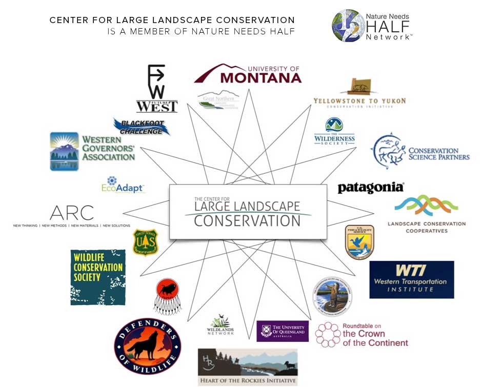 The Landscape Conservation Cooperative Network (LCCN), "is the collective of the 22 LCCs collectively", whose council consists of the BLM, USFS, NPS, USFWS, among others; NGOs NatureServe and TNC; four international participants; and the CLLC.
The Network for Landscape Conservation (NLC), was created by the University of Montana and Lincoln Institute for Land Policy (LILP). Their mission is "helping people work effectively across boundaries to...protect...or connect natural systems at the large landscape scale...", and support an "enduring system of protected and connected natural systems at the large landscape scale." Gary Tabor and Michael Whitfield are on the coordinating committee. The LILP has a Large Landscape Conservation Strategic Framework for Policy and Action. The WGA plans to launch a pilot project for wildlife mapping, identifying areas where development can occur with minimal impacts to wildlife, with Island Park being one project areas. Phase 1 includes inventorying species, habitat, unfragmented landscapes, protected habitats, and geographic features while evaluating connectivity tools and models in cooperation with NatureServe and WCS ongoing efforts to formulate connectivity best management practices. The project promises to contact all relevant stakeholders within the pilot area at the initiation of the project, including but not be limited to: Y2Y, WCS, and TNC. The project intends to hold at least 2 "stakeholder" meetings, with Island Park being one of those communities. By the end of Phase 1 they plan on having a "Completed connectivity/linkage plan identifying steps, tools, and outcomes for producing a connectivity data layer for the entire ID‐MT divide project area." The NGOs and HD must be thrilled. No start date was listed. The Brainerd Foundation funds the NGOs Earthjustice, TNC, SC, WS, and NWF; COC, GYC, Y2Y, FW, and HOR initiatives; the Henry's Fork Foundation and Sonoran Institute. The Sonoran Institute partners with the TNC, WS, BLM, USFWS, NPS, and the Bureau of Reclamation. The Wilburforce Foundation (WCS partner) funds Y2Y, and the Turner foundation also funds these agendas. As one can see, there are a substantial number of groups involved in this connectivity agenda, as well as money pouring in from wealthy individuals with the same ideology, and your tax dollar. But where are the voices whose heritage is bonded and connected to Island Park? Their voice, with first rights in importance, has been left out. The US 20 Corridor has a website specific to the Targhee Pass Environmental Assessment (EA) phase of the project. It states ITD, following National Environmental Policy Act (NEPA) requirements, is initiating an EA to evaluate risks, benefits, opportunities and costs associated with reconstruction of Targhee Pass, with the Federal Highway Administration (FHWA) as the lead agency. ITD has been studying the US 20 transportation corridor for 13 years, working with IDFG and the Henry's Fork Legacy Project (HFLP), assessing its condition, and identifying necessary improvements. Three studies were conducted during that time. 2014 (Cramer) - Methodology for Prioritizing Appropriate Mitigation Actions to Reduce Wildlife-Vehicle Collisions on Idaho Highways; 2014 (Seidler) - US 20 Island Park Wildlife Collision Study - an examination of Road Ecology in the Island Park Caldera: Elk and Moose migration across US Highway 20 - Final Report; and 2016 (Cramer) - Safety Solutions for Wildlife Vehicle Collisions on Idaho’s US 20 and SH 87. Technocrats and individuals from outside the area have the lead voice here. According to the website it was also during this time "one-on-one conversations with local agencies, municipalities, tribes and other key stakeholders" also took place, which were used for the Targhee Pass Environmental Study. ITD states comments on wildlife vehicle collisions (WVC) were "received in the scoping phase" of the study. Aside from the IDFG, HFLP, and technocrats, who? What Tribes? The website states the NEPA process begins when a federal agency develops a proposal to take a major federal action or (as in this case) when federal funds would be utilized to implement a project. Federal funds were approved for this project in October, 2016. So the NEPA process was started prior to the funding? What does federal law say? § 23 CFR 771.119 Environmental Assessments, § 771.111 Early coordination, Public involvement, and Project Development, and § 450.210 Interested parties, Public involvement, and Consultation, all require public involvement for transportation planning and actions requiring an EA. This is accomplished through an early coordination process and is incorporated into the EA which should be available for public inspection. One or more public hearings...at a convenient time and place for any...project which requires significant amounts of right-of-way, substantially changes the layout or functions of connecting roadways...or has a substantial adverse impact on abutting property are also part of the law. The state is also required to develop and use a documented public involvement process that provides opportunities for public review and comment at key decision points. What opportunity for involvement were citizens granted during the studies, or even from the beginning 13 years ago? § 23 USC 128: Public Hearings states, "Any State transportation department which submits plans for a Federal-aid highway project involving the by passing of or, going through any city, town, or village, either incorporated or unincorporated, shall certify to the Secretary that it has had public hearings, or has afforded the opportunity for such hearings, and has considered the economic and social effects of such a location, its impact on the environment, and its consistency with the goals and objectives of such urban planning as has been promulgated by the community." The ITD excluded all of this. Were public hearings held regarding proposed actions on the corridor, during a time when all were in residency? The website claims "The first step in the environmental assessment process is called scoping. This is an opportunity for the community to help identify issues and concerns specific to the study corridor." According to their timeline a study initiation and stakeholder assessment occurred in October, 2016. One public meeting was held in December with comments incorporated to refine alternatives and impact assessment methods in January, 2017. The subsequent April meeting was cancelled. The ITD Corridor Planning Guidebook mandates public participation and county official involvement at the beginning of any proposed project. Does it sound like the public and county criteria were met? How could it be the initiation of the project when studies had already been conducted, deals were made with other agencies, and only select groups involved? Community based organizations are also listed as important groups for outreach. Aside from the HFLP, the majority who don't live in Island Park, what other community based organizations were contacted? Island Park residents should give serious consideration to creating a Civic Advisory Committee for transportation decisions, separate from NGOs and select groups, for comprehensive perspectives. More importantly, this project should be started over and conducted according to the law. The ITD has clearly failed in meeting the public involvement requirement during the transportation planning. Open houses were scheduled during months when the majority were not in residence, and when the most difficult winter road conditions existed. A public hearing was never offered during a time when all were in residency. In addition, required socio-economic factors were clearly not included in the proposal or in any of the studies. Is it possible neither the NGOs or the ITD wanted the truth to come out? If this Targhee Pass project moves forward, Island Park better prepare for possible land use planning changes that will follow. As previously mentioned, Northwest Property Owners Association (NWPOA) went through this nightmare but successfully stopped it. Their local NGO attempted to incorporate restrictive regulations into their county comprehensive plan which included: requirements for using qualified design professionals; assessments and studies for professional design and best management practices; zoning restrictions; impact fees; development moratoriums; growth limits; and incorporation of state and/or federal laws. ScienceDirect has an excellent article, Land use planning: A potential force for retaining habitat connectivity in the GYE and Beyond, that is full of the scams taking place now, including the belief that "...counties could exert more power in controlling private land development." Defenders of Wildlife promote using State Wildlife Action Plans to link conservation with land use planning. Both are worth reading to understand future agendas if this connectivity project moves forward. Conclusion in Part 6. |
Concerned Idahoans:This website is non-partisan and is solely dedicated to removing the harmful controls placed on our state and nation through associated programs of Agenda 21, Agenda 2030, and the Great Reset. We invite all Idahoans to join us in this fight for freedom! Categories
All
Archives
April 2024
|
 RSS Feed

